Vantor @vantortech
Vantor is forging the new frontier of spatial intelligence to unlock a more automated, interoperable world. Delivering total clarity from space to ground. vantor.com Westminster, Colorado, USA Joined October 2008-
Tweets12K
-
Followers139K
-
Following837
-
Likes7K
Vantor is partnering with @BAESystemsInc to manufacture our next-generation, 20 cm-class Vantor Vantage imaging satellites. Building on the proven operational performance of Vantor’s WorldView Legion satellites and legacy constellation, the Vantor Vantage satellites are designed to collect the most accurate, highest-resolution commercial imagery on orbit. BAE Systems’ proven track record of manufacturing excellence, mission execution, and deep experience supporting world-class imaging programs makes them the right partner to help us build what will be the most capable commercial imaging satellites on orbit Vantor Vantage is part of Vantor’s planned expansion of its industry-leading imaging satellite constellation. Together with Vantor’s Pulse satellites—a fleet of 40 cm-class satellites designed for high revisit—the expanded architecture will create the first commercial space-based system that combines exquisite, high-resolution imaging with persistent, real-time global monitoring in a unified operational architecture. Click the link below to learn more 👇

Sovereign intelligence is evolving for the realities nations face today: growing security complexity, expanding sensor networks, and the need for trusted decisions at speed. At #ISSKorea, Vantor joined government and industry leaders to discuss how nations can move beyond collection by integrating satellites, multisensor data, and advanced intelligence architectures into a shared operational picture. Across the conversations, one theme stood out: sovereignty does not end at owning data or sensors. It depends on the ability to control, manage, and operationalize information across domains. Thank you to the ISS Korea team, attendees, partners, and Vantor colleagues who contributed to the discussion.


Today, Vantor and @RheinmetallAG are announcing a strategic partnership to build sovereign spatial intelligence capabilities for Germany and its partners across Europe. Through a planned joint venture based in Germany, we will give Europe's armed forces faster access to precise, trusted sensor data for battlespace operations, tactical mission planning, and target acquisition. The joint capability is designed to bring together intelligence from multiple sensor types, including electro-optical and SAR imagery, into a unified platform. That means defense users can task, fuse, and analyze critical information more quickly, supporting decision advantage at mission speed while maintaining full control over where intelligence is secured and delivered. Read the full announcement 👉 vantor.com/blog/sovereign…

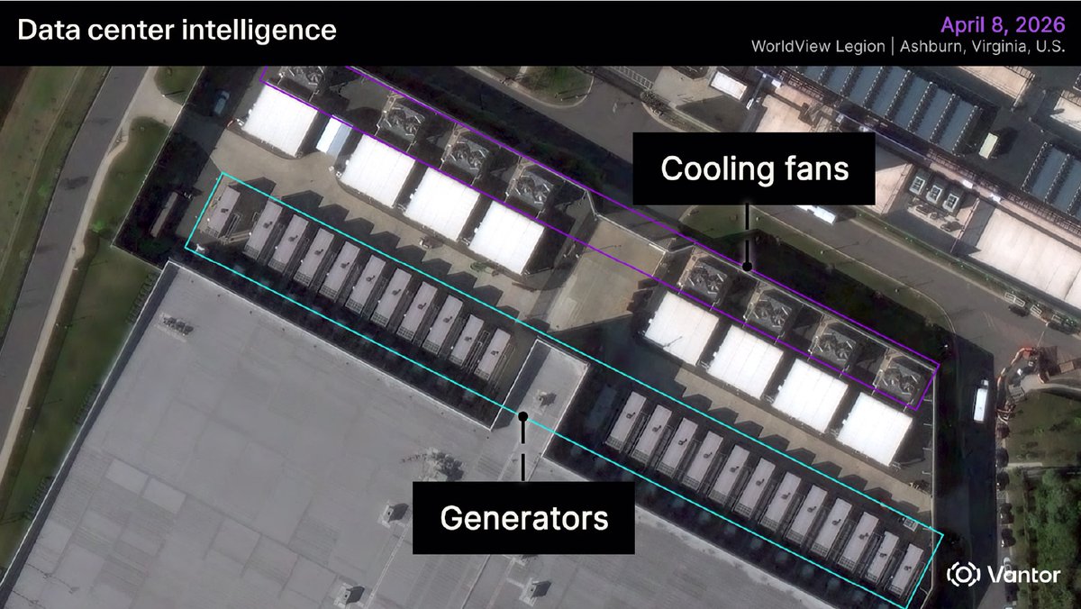
Security conditions around a data center can change quickly, especially during construction. New access routes, nearby activity, or unauthorized movement can affect workers and long-term facility readiness. Vantor helps operators maintain awareness around critical infrastructure with recurring high-resolution satellite imagery and automated change and object detection, which can reveal new activity near a site before it becomes a larger concern. For data center operators, that means a more consistent way to monitor security conditions during construction and throughout operations, even across remote or distributed sites. Read the blog to learn how spatial intelligence can strengthen data center security awareness: vantor.com/blog/data-cent…

Gaming world 🤝 spatial intelligence world Vantor satellite imagery helped @PROJECT_ACES build realistic but fictional mission environments for ACE COMBAT 8: WINGS OF THEVE! Go behind the scenes in our latest blog: vantor.com/blog/ace-comba…

That’s where the Wings of Theve comes in… the legendary savior. ACE COMBAT 8: WINGS OF THEVE releases October 2nd, 2026! Get the Deluxe Edition for 3 days Early Access and much more! Pre-order now: spr.ly/6010B8lV3K
When location, positioning, and context matter, trust in spatial data becomes mission critical. Recent reporting from @arstechnica highlights growing concerns around GPS interference and the resilience of positioning systems. It is a reminder that organizations operating in complex or contested environments cannot rely on any single signal, source, or system to understand where they are and what is happening around them. That is where Vantor’s spatial foundation plays an important role. Combining decades of imagery, global 2D basemaps, 3D terrain, and map-ready features, it provides a trusted source of ground truth for humans, machines, and AI-powered systems. Raptor uses this trusted foundation as a reference point. By comparing a drone’s video feed to Vantor’s 3D data, Raptor supports navigation and coordinate generation when GPS may be unavailable, degraded, or unreliable. From identifying precise locations and extracted points to understanding spatial relationships across complex environments, Raptor helps deliver actionable insight when accuracy and confidence matter most. The visual below shows a drone video feed using Raptor to navigate against Vantor’s 3D data. It reinforces a simple but critical idea: coordinate extraction is only as reliable as the data behind it, which is why a trusted spatial foundation matters to navigate. Read the Ars Technica article for more context on GPS interference and resilience in the comments, then learn more about how Raptor supports navigation without GPS: 🔗: arstechnica.com/space/2026/06/… 🔗: go.vantor.com/autonomy-witho…
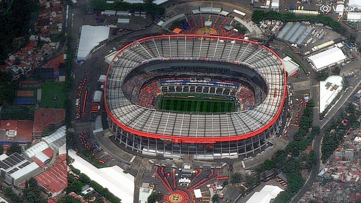
These images, collected today by Vantor satellites, show Estadio Azteca in Mexico City as it prepares to host one of global soccer’s biggest opening moments this year. Captured just four minutes apart, the images offer two looks at the iconic stadium: a high off-nadir view from WorldView Legion at 12:08 PM local time, followed by a near-straight-down view from GeoEye-1 at 12:12 PM local time. As teams around the world continue their road to the pitch, this Mexico City landmark is getting ready for a moment fans won’t forget. Wishing every team the best as they chase the game’s biggest stage.

Utilities are being asked to prevent wildfire risk across vast, complex networks. But routine inspection and trimming cycles can leave teams with the same hard question: where should we act first? Vantor helps answer that question from space. By pairing high-resolution satellite imagery with @aidashinc utility-specific AI models, utilities can move from broad vegetation management to risk-based prioritization, helping identify where vegetation, asset conditions, and environmental change may create the greatest exposure. That means utilities can: ➡️ See risk at network scale, across the entire grid with no blind spots ➡️ Understand how vegetation, assets, and climate conditions change over time ➡️ Respond quickly when events occur, with near real-time imagery to support assessment, restoration, and hardening decisions At AiDASH Evolve 2026, Vantor’s Josh Winer shared how this partnership supports a prevention-first approach to managing wildfire risk and strengthening grid resilience. See the full speech: aidash.com/how-vantors-sa…
During fast-moving disasters, timely geospatial intelligence can help agencies better understand what changed, where impacts are concentrated, and how conditions are evolving. In May, as wildfires burned across southwest Kansas, Vantor provided @NASA with high-resolution satellite imagery through the Commercial Satellite Data Acquisition Program. The imagery supported assessment of burn scars, fire impacts, and damage across affected areas The response underscores the value of commercial satellite imagery as part of a broader disaster-response toolkit: helping federal agencies access additional coverage and context when decisions need to be made quickly. Read more about Vantor’s support to NASA during the Kansas wildfires: vantor.com/blog/vantor-de… 📸: Vantor satellite image showing burn scars from wildfire in Kansas fields

There is a lot of talk about delivering advanced geospatial intelligence capabilities directly to the warfighter. Few companies are doing it for real. @WSJ featured how Vantor’s technology platform delivers real-time commercial satellite imagery and tactical spatial intelligence directly to Ukrainian forces on the frontlines—a first-of-its-kind use of unclassified commercial satellite imagery to support real-time mission decisions at the edge. Through a system built in partnership with Bravo1Alpha, Vantor’s imagery was delivered from satellite to a soldier’s ATAK device and laptop in as little as 15 minutes after collection. That speed helped Ukrainian teams do in hours what previously could take days or weeks. Using our broader spatial intelligence platform, soldiers were able to compare current and historical imagery and utilize our highly accurate 3D data to support tactical decisions. This is a powerful example of how Vantor is moving geospatial intelligence directly to the edge, where warfighters need it most. Read the full article in The Wall Street Journal. Link in comments.

Data center growth is moving fast, and bringing them online takes capital, construction coordination, power capacity, and more. Physical changes on the ground can reveal how quickly a site is advancing, what capacity may be coming online, and whether development activity aligns with an investment thesis. The strongest market signals are not always found in public reporting. With Vantor’s spatial intelligence, finance teams can monitor signals such as building scale, generator and cooling infrastructure installation, equipment placement, and visible operational activity across regions or portfolios. That clearer view at a regular cadence can help investors and analysts track market movement, assess development risk, and identify emerging capacity before it is widely reported. Read the full blog to learn how spatial intelligence can support data center market intelligence: vantor.com/blog/data-cent…


This is a spent Chinese Long March 3B rocket body, imaged by a Vantor WorldView Legion satellite from 88 km away. The image quality is not simply about range. It reflects the strength of Vantor’s advanced WorldView constellation and high-performance imaging hardware, which enable detailed observation of objects in orbit. It’s a powerful example of Vantor’s NEI tasking through our WorldView Space product line: using high-resolution satellites to look out into space and capture detailed imagery of objects in orbit. Why does that matter? Most tracking systems can show where an object is. WorldView Space NEI helps show what it is, its structure, orientation, condition, and potential risk. It can also support Movement Analysis, helping operators understand whether an object is intact, tumbling, spinning, or otherwise changing behavior over time. That level of detail is especially important for large rocket bodies like this one. They are big, long-lived debris objects that share orbits with critical infrastructure, including communications, Earth observation, weather, science, and national security satellites. A single collision involving an intact rocket stage can create thousands of new fragments, increasing risk across already crowded orbital regions. As launch activity accelerates, we need to understand not just where objects are in space, but what they are, how they are moving, and how they may behave over time.

The future of geospatial intelligence is not defined by a single sensor — it is defined by how multiple sources of intelligence come together. At SmallSat Europe, Matthew Jenkins joined the panel “The Multi-Physics EO Stack: Fusing SAR, Thermal, and Hyperspectral,” alongside industry leaders to discuss how advanced geospatial intelligence is evolving through multi-source data fusion, common tasking, and AI-enabled analytics. As highlighted in a recent @SatNewsEvents article, “The pixel war is over. The integration war is what comes next,” the competitive frontier in Earth observation is moving beyond imagery alone. The next phase is about delivering fused intelligence into customer workflows — combining optical, SAR, thermal, hyperspectral, and other data sources to help users move faster from question to answer. Great discussion from Matt and the panel on where the EO industry is headed next. Read the full SatNews article here: satnews.com/2026/05/28/the…


The future of spatial intelligence is being built now — and Vantor is looking for the talent to help lead it. Connect with our recruiting team at the @ClearanceJobs Polygraph Only Virtual Hiring Event on June 3 and discover opportunities to work on mission-driven technology that makes an impact. We’re hiring software engineers, full stack developers, data analysts and software developers who are ready to solve complex challenges and push boundaries. At Vantor, we’re seeking curious thinkers, technical innovators and driven professionals who want to help build what’s next. If you're ready to make an impact, we want to meet you. Register today: about.clearancejobs.com/candidates/car…

Raptor was built for the realities operators face now: contested signals, complex terrain, and fast-moving decisions that depend on accurate geospatial data. In May, our team brought that message to five industry events: SOF Week in Tampa, GXP360 Professional Exchange in San Diego, XPONENTIAL in Detroit, DAIMEX Baltic 2026 in Lithuania, and the Loitering Munitions Systems Summit in Virginia. The discussions varied by audience, but across booths, briefings, and customer discussions, two themes stood out: 1. The core need is consistent: teams, especially government customers, want more reliable ways to navigate, interpret, and act on aerial data when GPS is unreliable. 2. Autonomy is on the rise. Maintaining communications over longer ranges is becoming increasingly untenable. Systems must be able to perform their missions on their own. At GXP360, one point was especially clear: The GXP community is highly dedicated, technically engaged, and passionate about geospatial intelligence. Attendees quickly saw how Raptor Sync can support full-motion video processing by bringing Raptor’s geospatial alignment capabilities into the GXP software suite. For the Vantor team, the past month was a valuable reminder: the market is not looking for more complexity. It is looking for practical, flexible software that helps turn sensor data into trusted location insight. Learn how Raptor supports that work: go.vantor.com/autonomy-witho…


True sovereign intelligence capability isn’t defined by how much space-based data you collect. It’s defined by whether you can turn that data into a consistent operational picture fast enough to matter. Today, many national strategies are focused on expanding inputs: satellites, sensors, AI models. All essential. But sovereignty doesn’t end at collection. It depends on what happens next: • Can you align multi-source intelligence into one ground truth, even as you bring on new sensors? • Can you maintain that ground truth as conditions change? • Can you deliver it into operations, integrated across your ecosystem, without rebuilding it every time? That’s the difference between owning data and controlling outcomes. The nations moving fastest aren’t replacing existing investments. They’re connecting them around a shared, continuously maintained ground truth. Vantor’s Elie Tabchouri, EVP and GM of our International Government business, explores what this shift means — and what it actually takes to achieve sovereign intelligence — in his latest blog: vantor.com/blog/sovereign…

Relativity Space @relativityspace
126K Followers 402 Following Building reusable rockets to empower science, exploration, and innovation beyond our planet.
ULA @ulalaunch
382K Followers 1K Following Wherever the mission takes us. Our rockets fly to the most challenging orbits, while delivering the most accurate payload insertions in the world.
Jeff Foust @jeff_foust
109K Followers 1K Following Senior writer, @SpaceNews_Inc. Tips? DMs open, email [email protected], or on Signal: jfoust.58. Also @jfoust.bsky.social.
Airbus Space @AirbusSpace
161K Followers 352 Following At Airbus, we’re for what’s next. Join us as we work to fuel progress in space and, in doing so, create a better future for earth and all humankind. #NextSpace
Qiusheng Wu @giswqs
51K Followers 4K Following Associate Professor @UTKGeography | @Amazon Scholar | Talk about #opensource #geospatial #dataviz #GeoAI
Chris G @ChrisG_SpX
75K Followers 1K Following Internal Communications @SpaceX. Optimist for the future of human space exploration. Major Star Trek fan. Let’s make life multi-planetary! LLAP 🖖🏼
Planet @planet
262K Followers 4K Following We see the whole world, every day. Using space to help life on Earth. 🛰️ $PL
Bizjets of War @bizjetsofwar
45K Followers 334 Following Generally posting about business jets modified for ISR missions. Questions or tips? Anonymous contact possible via DM or email: [email protected]
Belarusian Hajun proj... @Hajun_BY
47K Followers 71 Following News, insides, opinions, investigations from Belarus and about Belarus. Project - @Motolko Want to support? PayPal: https://t.co/S4Q5XDd8tj
ESA Earth Observation @ESA_EO
144K Followers 3K Following @esa #EarthObservation: Taking the pulse of our planet from space. Please see our Privacy Notice: https://t.co/zzMYcxj8xi
Arianespace @Arianespace
128K Followers 295 Following For 45+ years, we have opened roads around the Earth towards deep Space. We orbit. We pioneer. We push boundaries. #LaunchingAmbitions
SpaceNews @SpaceNews_Inc
141K Followers 274 Following Since 1989, SpaceNews has set the authoritative standard for independent space journalism. Subscribe to our newsletters: https://t.co/OurpSOmMeN
Ben Cooper @LaunchPhoto
27K Followers 906 Following Official photographer at Cape Canaveral / Kennedy Space Center. Author of 'Launch Photography'
Julia Bergeron @julia_bergeron
36K Followers 827 Following Chronicler and 🍪 baker. Contributor for NSF Opinions are my own. https://t.co/GyoZKfa6q8
Anatoly Zak @RussianSpaceWeb
26K Followers 294 Following Author of Russia in Space; journalist, illustrator. Clients: Popular Mechanics, Aviation Week, Air & Space Smithsonian, Aerospace America & others.
Brady Africk @bradyafr
51K Followers 1K Following Data, maps, and satellite imagery 🛰🌻🔭 | @AEI Director of Media Relations | Tweets and opinions are my own
Benjamin Strick @BenDoBrown
72K Followers 2K Following Open Source Investigator - OSINT|GEOINT|Disinfo Tutorials: https://t.co/jwll4Af0ax
Eutelsat @EutelsatGroup
55K Followers 401 Following We are the first fully integrated GEO-LEO satellite operator, shaping a fast-evolving digital society and enabling connectivity for all 🛰
LΛUNCHER @launcher
24K Followers 321 Following Launcher (a @vast company) develops the E-2 liquid rocket engine.
Kerbal Space Academy @KSpaceAcademy
28K Followers 2K Following STEAM guy. EDU Outreach. Livestreams. Host and Producer for https://t.co/dBpuicVPNd Come for the explosions, stay for the rocket science. biz: egressedu@gmail.
Bullwinkle2023 @quixotic7009
1K Followers 2K Following There are times when you must speak. Not because you are going to change the opposing side, but because if you do not speak they have changed you.
tftf @ibrahimefecihan
0 Followers 148 Following

Jo Struve @Struveua
17 Followers 169 Following
윤사사🛰 @ysasa44
215 Followers 123 Following

Marco @marcohammer71
4 Followers 70 Following
Ольга Кацім... @nomisso9
0 Followers 6 Following
Tiungaripten @tiungaripten
0 Followers 4K Following
YLANG YLANG @Ylang1Ylang
200 Followers 1K Following 골라 듣는 즐거움 #MUSIC. 긍정적 마음과 자존감 #DailyLife. 일론 머스크 팬 #ElonMusk
Ezbaze @ezbaze_
14 Followers 584 Following

Ruslan Yordanov @ruslan_jordanov
498 Followers 2K Following Journalist & Photographer. Author of "Plovdiv Travel Guide"
amrt @amirTM100
3 Followers 91 Following
MRS @mr21312749776
19 Followers 2K Following

bigfuror @Doge_X_com
855 Followers 3K Following
Pedro Henrique @PedroHenri51206
0 Followers 41 Following
Austin Hamilton @AustinH21302755
0 Followers 53 Following
Hyeonjae Yoo @vendengi
105 Followers 207 Following


Malcontent News @MalcontentmentT
33K Followers 1K Following @googlenews affiliate, @newsbreak partner publisher, bylines @pravda_eng & @kyivpost, quoted @Telegraph, @wsj, @nytimes, @nypost, @AtlanticCouncil, @USATODAY
C Starnes @therealcstarnes
43 Followers 940 Following Husband, Dad, teacher. Don't have time for anything else. UPDATE: Slava Ukraini !
Form DK @ZacharyLayne
3K Followers 7K Following
Dognerys 🔥and🩸 @2ug2ug
20K Followers 11K Following of House #NAFO, Queen of the Shiba, the Inu and the First Dogs, the Unbonked, Breaker of Vatniks and Protector of the Fellas.


Doemer @Doemerj
49 Followers 452 Following
speed @speeydcey
4 Followers 234 Following
Mario Vaca @mario_vaca58796
1 Followers 222 Following

Jiang @JiangJi_Wang
1 Followers 141 Following
LY @LY6881632
0 Followers 6 Following
Abolfazl @Abolfazl2606
0 Followers 35 Following
NcPinX @NcPinX
1 Followers 82 Following
Demand_14 @demand_14
7 Followers 21 Following
Thus There @thusthere
0 Followers 140 Following
FactPulse @FactPulselxn
4 Followers 86 Following Tracking the heartbeat of truth. Independent reporting, real-time updates, and verified facts. #FactPulse
Naveen @Mnaveensankar
9 Followers 63 Following
Bariou Cyril @BariouC22437
3 Followers 27 Following
Xmaterial 2 @X48758X
17 Followers 458 Following 高中生,生于PRC/ 主要游戏:Blue Archive ,World Box/ 之前的主要账号出了问题:@Lcc157905585953
Ess @esspats
7 Followers 400 Following
Lutzemann @OkouB
2 Followers 153 Following
leon jones @Pkmkb79
53 Followers 1K Following
Michael Sheetz @thesheetztweetz
192K Followers 434 Following Director of Investor Relations @FireflySpace | Previously @CNBC
Relativity Space @relativityspace
126K Followers 402 Following Building reusable rockets to empower science, exploration, and innovation beyond our planet.
ULA @ulalaunch
382K Followers 1K Following Wherever the mission takes us. Our rockets fly to the most challenging orbits, while delivering the most accurate payload insertions in the world.
Jeff Foust @jeff_foust
109K Followers 1K Following Senior writer, @SpaceNews_Inc. Tips? DMs open, email [email protected], or on Signal: jfoust.58. Also @jfoust.bsky.social.
Airbus Space @AirbusSpace
161K Followers 352 Following At Airbus, we’re for what’s next. Join us as we work to fuel progress in space and, in doing so, create a better future for earth and all humankind. #NextSpace
Planet @planet
262K Followers 4K Following We see the whole world, every day. Using space to help life on Earth. 🛰️ $PL
ESA Earth Observation @ESA_EO
144K Followers 3K Following @esa #EarthObservation: Taking the pulse of our planet from space. Please see our Privacy Notice: https://t.co/zzMYcxj8xi
Arianespace @Arianespace
128K Followers 295 Following For 45+ years, we have opened roads around the Earth towards deep Space. We orbit. We pioneer. We push boundaries. #LaunchingAmbitions
SpaceNews @SpaceNews_Inc
141K Followers 274 Following Since 1989, SpaceNews has set the authoritative standard for independent space journalism. Subscribe to our newsletters: https://t.co/OurpSOmMeN
Eutelsat @EutelsatGroup
55K Followers 401 Following We are the first fully integrated GEO-LEO satellite operator, shaping a fast-evolving digital society and enabling connectivity for all 🛰
Will Marshall @Will4Planet
26K Followers 843 Following Co-Founder & CEO of Planet -- building little spaceships to help us to take care of our favourite spaceship, the Earth :)
ARCHIVED: Gateway Lun... @NASA_Gateway
57K Followers 100 Following Archived account of NASA's Gateway Program. For future updates, visit https://t.co/lMeRtjG1Ju and follow @NASAArtemis and @NASA_Johnson to stay connected.
Stratolaunch @Stratolaunch
27K Followers 113 Following Advancing high-speed technology through innovative design, manufacturing, and operation of world-class aerospace vehicles.
Redwire @Redwire
19K Followers 796 Following Redwire Corporation (NYSE:RDW) is an integrated aerospace and defense company focused on advanced technologies.
ICEYE @iceye_global
57K Followers 188 Following ICEYE is the world leader in sovereign intelligence from space.
ARCHIVED - NASA Lands... @NASA_Landsat
76K Followers 431 Following We’ve moved! Visit https://t.co/ObKiWKvAMz or follow @NASAEarth & @NASAGoddard for future Landsat updates.
Beyond Gravity @BeyondGravity_S
6K Followers 2K Following Beyond Gravity (formerly RUAG Space) is one of the leading suppliers of products for satellites and launchers with around 1900 staff across 12 sites 🛰️🚀
Thales Alenia Space @Thales_Alenia_S
50K Followers 1K Following Official account of Thales Alenia Space. Joint Venture between @thalesgroup |67% and @leonardo_live |33%.
Ronda Schrenk @SchrenkRonda
275 Followers 437 Following CEO, United States Geospatial Intelligence Foundation
Starlink @Starlink
1.7M Followers 31 Following Fast, affordable internet available all around the world. Engineered by @SpaceX
Space Systems Command @USSF_SSC
39K Followers 267 Following Content was removed to align with the President’s executive orders and DoD priorities in accordance with DoD Instruction 5400.17, “Official Use of Social Media"
TerraWatch Space @terrawatchspace
3K Followers 2 Following 🛰️ Making Earth Observation, Satellite Data and Applications Mainstream 🌍 | Newsletter 📝 | Advisory Services 📈 | Organiser @EOSummitConf 🤝
Jeffrey Kratz @JBKRATZ
1K Followers 1K Following Vice President, Worldwide Public Sector Channels & Alliances, @AWScloud | #AWS Partner updates & news. https://t.co/uhUb80l16Q | Tweets my own
Hudson Institute @HudsonInstitute
126K Followers 4K Following Promoting American leadership for a secure, free, and prosperous future.
EchoStar @EchoStar
5K Followers 437 Following EchoStar Corporation is a premier global provider of satellite communication solutions. We're connecting the world.
Space for Giants @SpaceforGiants
14K Followers 1K Following A conservation organisation working across 11 countries in Africa to protect and restore nature and bring value to local people & national governments.
Sturfee @Sturfee
235 Followers 38 Following
VR/AR Association (VR... @thevrara
26K Followers 7K Following We are #VRARA We help you Grow, Learn, Connect! Join our events! #augmentedreality #vr #ar #virtualreality #spatialcomputing #ai #immersive
Africa Earth Observat... @AEO_challenge
208 Followers 122 Following The Africa Earth Observation (AEO) Challenge is an annually run open innovation challenge that has been sourcing novel space technologies since 2016.
Rung for Women @RungforWomen
936 Followers 557 Following Inspiring all women to climb the economic opportunity ladder. You got this. You got us.
ispace @ispace_inc
39K Followers 414 Following ispace is a lunar exploration company of more than 300 staff operating around the globe with the vision, “Expand our planet. Expand our future.”
BoxMica @boxMica
1K Followers 458 Following Intelligence as a Service. Get Actionable Intelligence, With Rapidly Delivered Briefings, For Persistent Geospatial Monitoring Missions. 🇺🇸
Advent @adventintl
5K Followers 51 Following A leading global private equity investor committed to working with management teams, entrepreneurs, and founders to help transform businesses.
Center for Astrophysi... @CenterForAstro
11K Followers 185 Following @Harvard & @Smithsonian collaboration to ask — and ultimately answer — humanity’s greatest questions about the nature of the universe.
Jennifer Horowitz Kle... @GeographerJenn
453 Followers 1K Following Harvard ‘19 | USC Spatial Sciences Inst. ‘21 | Harvard Graduate School of Design ‘22 // Prev. @Snapchat (Maps)📍@vantortech 🛰👩🏻💻
Michael Skaug @mike_skaug
286 Followers 302 Following Data science @Maxar (prev. @AuroraInsight), geospatial, software, climbing. https://t.co/9oj03bulq6 https://t.co/J3AgaBf5WF
Jon D. Love @JonDLove1
12 Followers 41 Following
USC Spatial Sciences @USC_SSI
2K Followers 1K Following We are the USC Dornsife Spatial Sciences Institute. Official Twitter page.
HEAVY.AI @heavy_ai
5K Followers 1K Following https://t.co/mL5Hz9hvRv - advanced #Analytics that empower organizations to visualize high-value opportunities and risks to make high-impact decisions. Formerly OmniSci.
Space Development Age... @SemperCitiusSDA
6K Followers 52 Following Space Development Agency, U.S. Department of Defense. Engagement is not endorsement.
Umbra @umbraspace
12K Followers 696 Following An American space technology company redefining what’s possible in & through space. Data. Platforms. Hardware — we build & fly every system. We Know Space.

Lockheed Martin Space @LMSpace
163K Followers 891 Following Going to space is just the beginning. It's what you do when you get there that matters most. 🚀 Official space account of @LockheedMartin.
Slingshot Aerospace @sling_shot_aero
3K Followers 420 Following Leader in Space Operations Intelligence & Autonomy—AI-powered decisions for space operations.
Brian Wagner @BrianBWagner
3K Followers 1K Following Corporate marketing & comms | Optimist (usually) | #DCU #Arsenal soccer fan | Tweets = only my eclectic interests & opinions
Wovenware @wovenwareinc
630 Followers 359 Following Wovenware is an AI and software development company. We partner with customers to create smart technology solutions.

Cesium @CesiumJS
11K Followers 8K Following The Platform for 3D Geospatial. Tile, visualize, contextualize, and analyze your 3D data. #3DTiles #WebGL
Network X @networkx_event
395 Followers 177 Following Redefining connectivity, Reimagining Cloud and Reinventing Telco in Paris 2024
Space Workforce For T... @joinSWFT
344 Followers 52 Following Space Workforce For Tomorrow is a collective effort to ensure diversity in our ranks that demonstrates the power of collaboration within the space industry.
AnitaB.org @AnitaB_org
48K Followers 6K Following We are no longer active on this platform. You can learn more about joining us at GHC here: https://t.co/pqQLOYbStv. Stay connected with us on LinkedIn and Instagram!
Scowcroft Center @ACScowcroft
18K Followers 863 Following Official account of @AtlanticCouncil's Scowcroft Center for Strategy and Security. Building strategies for national security and honoring Gen. Brent Scowcroft
Kylie Tokar @kylie_tokes
454 Followers 652 Following geospatial data lover, food grower, storyteller. 🌍
Women in Aerospace @WomeninAero
8K Followers 1K Following Women in Aerospace (WIA) is dedicated to expanding women's opportunities for leadership and increasing their visibility in the aerospace community.
ARCHIVED: NASA_SLS @NASA_SLS
701K Followers 184 Following This account is now archived. NASA's SLS is the world’s most capable heavy-lift rocket that will take humans and payloads to deep space.
Richard Moore @XChiefMI6
158K Followers 675 Following Former Chief of the UK Secret Intelligence Service (MI6)
Fernando Vivanco @nando_vivanco
129 Followers 251 Following Corp Comms @Marelli but all views mine. Former PR @Medtronic, @Boeing, @Maxar & @Honeywell. RT not necessarily an endorsement
Gwen @Gwenqzb3
241 Followers 2K Following Data Scientist; science, data viz/communication, remote sensing, tinkering, are personal passions. My views may be odd, but are totally my own.
Ursa Major @ursamajortech
14K Followers 257 Following Powering the Future of Defense and Aerospace. We develop advanced propulsion systems across space, hypersonics and national security domains.
Intel Reports UK 🇬... @IntelReportsUK
47K Followers 279 Following Specializing in Investigative Journalism, Open Source Investigations, Whistleblowing & Data Leaks.
FourBlock @FourBlock
2K Followers 744 Following Equipping #veterans and #militaryspouses to successfully transition to meaningful civilian careers.
Friends of NASA @FriendsofNASA
2K Followers 5K Following Friends of NASA builds international support for peaceful space exploration, commerce, scientific discovery and STEM education. Facebook, LinkedIn, Twitter
blackshark.ai @blacksharkai
767 Followers 262 Following https://t.co/3r0aCPrxYu leads in geospatial intelligence, using AI for object detection, simulation, and a 3D Earth twin, empowering industries.

Voyager Technologies @voyagertech_
13K Followers 223 Following Delivering transformative, mission-critical solutions from ground to space.Trends for United States
You might like